
Click-to-call us:
Medina | Akron, OH
330-441-4916
Cleveland, OH
216-619-7979
Columbus, OH
614-358-2772
Pittsburgh, PA
412-223-9001
Toll Free Phone
877-AIR-PIX-6
(877-247-7496)
Toll Free Fax
877-AIR-PIX-5
(877-247-7495)
Above All - Ohio | Services | Verticals | Stock Photo Maps
| Obliques | Verticals | Video | Thermography | Aerial Lift | Construction | Architectural | Graphics |

| Near Verticals | True Verticals | Custom Photo Maps | Stock Photo Maps | Interactive & Geotagging |
|
Mouse over a photo to pause... |
Above All - Ohio is proud to be the re-seller in Ohio for Landiscor Aerial Information. Landiscor has current, high resolution (1-foot) imagery for all of Ohio's major metropolitan areas (Cleveland, Akron, Canton, Youngstown, Columbus, Cincinnati, Dayton, and Toledo). All imagery is GIS compatible with ArcGIS and MapInfo. We also have access to Landiscor's photo maps for most other metro areas throughout the country. Please give us a call today and let us know what you need - we are here to help you! |
|
Whether you need one square mile or an entire metro area, we can deliver digital images, prints, and wall-sized murals. We can fully customize your photo map with roads, labels, political boundaries, site outlines, demographics, and other useful information. Alternately, you can take complete control over the appearance, limits, and output of your photo maps yourself with Landiscor's optional viewing software. Training and tech support are included with the purchase of the software and it can be used by everyone in your office at no additional cost. Please contact us today for pricing information on all of our mapping imagery, software, and prints. We will work with you to come up with a mapping and viewing solution that best suits your needs! |
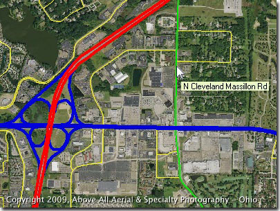
Partial screen capture of PhotoMapper software in action |
Above All Aerial & Specialty Photography - OhioOur images will work for you.℠ |
