Click-to-call us:
Medina | Akron, OH
330-441-4916
Cleveland, OH
216-619-7979
Columbus, OH
614-358-2772
Pittsburgh, PA
412-223-9001
Toll Free Phone
877-AIR-PIX-6
(877-247-7496)
Toll Free Fax
877-AIR-PIX-5
(877-247-7495)
Above All - Ohio | Services | Verticals | Near Verticals
| Obliques | Verticals | Video | Thermography | Aerial Lift | Construction | Architectural | Graphics |

| Near Verticals | True Verticals | Custom Photo Maps | Stock Photo Maps | Interactive & Geotagging |
|
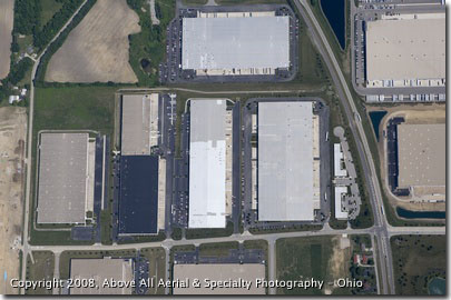
The most common type of vertical photo is called a "near vertical". Near verticals are done when a straight down view of a site is desired, but GIS information and engineering data are not required for your application. Single image near verticals are a cost effective option for areas from approximately 1.0 x 1.5 miles down to individual parcels and lots. Multiple near vertical images can be stitched together to cover larger areas, but it should be noted that the resulting image will not be as accurate as a photo map or a true vertical aerial survey. |
Above All Aerial & Specialty Photography - OhioOur images will work for you.℠ |
